.avif)
.avif)
.avif)
.avif)
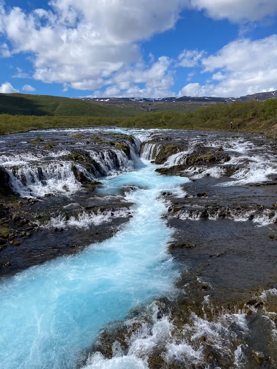
Brúarfoss is a strikingly beautiful waterfall in south Iceland, approximately 95 kilometers east of Reykjavík along the Brúará River. The name translates to "Bridge Falls," referencing a natural stone bridge that once spanned the river above the cascade but collapsed in the early 20th century.
The waterfall gained international attention through social media, with photographers drawn to its vivid turquoise-blue water, a color resulting from glacial minerals suspended in meltwater flowing from Langjökull glacier. Unlike many Icelandic waterfalls known for dramatic height, Brúarfoss measures approximately 2 to 3 meters in height but spans roughly 10 meters in width, creating multiple cascades through dark volcanic rock that produce remarkable color contrast.
The falls remained relatively unknown until the 2010s, when sudden popularity created access challenges on private land. In 2020, authorities closed the original western route and opened a new official trail from the Brúarárskógur forest parking area. This path covers approximately 4 to 5 kilometers round trip, taking 60 to 90 minutes to complete.
You'll follow the Brúará River through scenic countryside, passing smaller cascades before reaching Brúarfoss. The relatively flat terrain makes the hike accessible for most fitness levels, though you'll need proper footwear as sections become muddy after rain. The river's vivid color remains visible throughout the route, offering photographic opportunities beyond the main waterfall.
You can reach Brúarfoss by driving to the Brúarárskógur parking area via Route 37 and Route 355, following signs toward Brúarás hamlet. From Reykjavík, the journey takes approximately 90 minutes. From Geysir and the Golden Circle route, you'll drive about 30 minutes via Route 35.
Admission to Brúarfoss and the trail is free, though the parking area accommodates only 20 to 30 vehicles and fills quickly during peak season between 10 AM and 4 PM. Arriving early morning or later afternoon increases your chances of finding space.
No facilities exist at the trailhead, so bring water and snacks. The nearest services are in Laugarvatn, approximately 20 kilometers west, or at Geysir, roughly 25 kilometers northeast. Exercise caution near the water's edge, as rocks become extremely slippery when wet. You should allow 2 to 3 hours total for the hike and visit, including time for photography.
Bruarfoss is located near the Golden Circle route in Iceland. The waterfall can be reached via a moderate hike, approximately 3.5 kilometers (2.2 miles) from the parking area. The trail can be muddy or slippery, so good hiking shoes are recommended.
While Bruarfoss is family-friendly, the hike to the waterfall can be challenging for younger children due to uneven terrain and potentially slippery conditions. Families should assess their children's hiking abilities before visiting.
Bruarfoss is accessible year-round, but the best time to visit is during the summer months when the trail is easier to navigate. Winter visits can be more challenging due to snow and ice.
There are no facilities directly at Bruarfoss. The nearest amenities, such as restrooms and food options, are located in nearby towns along the Golden Circle route.
The trail to Bruarfoss is not always well-marked, and some sections can be difficult to follow. Using a GPS or a trail map is recommended to ensure you stay on the correct path.
Why should you?