%20(1).avif)
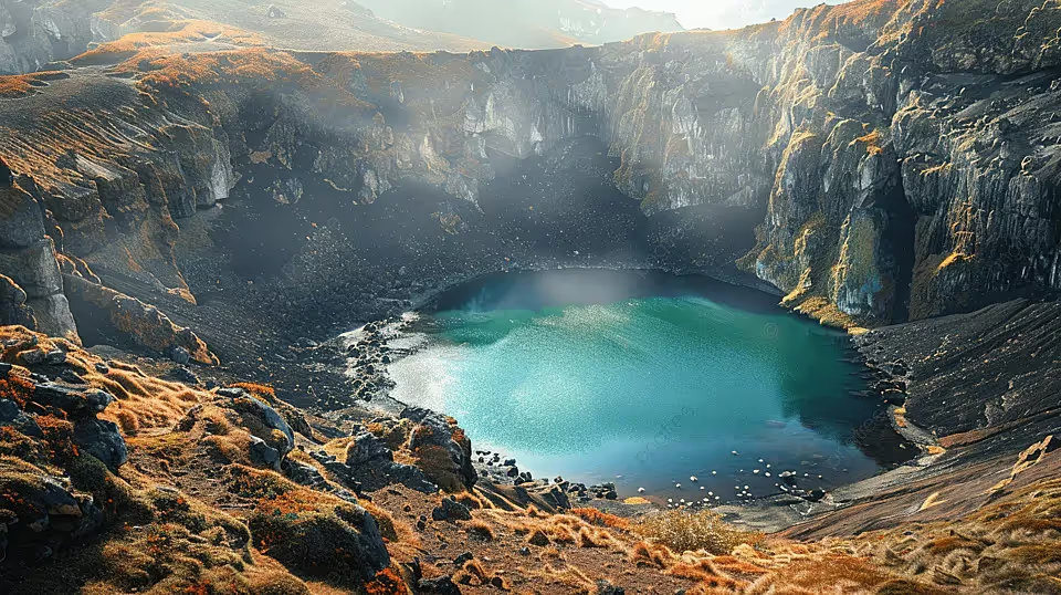
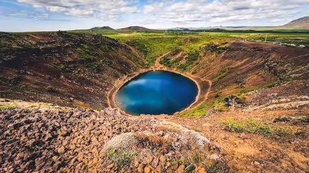
Kerid crater (also spelled Kerið, Kerio, or Kerith) is a volcanic crater lake located in the Grímsnes area of southern Iceland. It is one of the most visually striking geological features in the country — a deep elliptical caldera with vivid rust-red and orange volcanic walls plunging down to a brilliantly teal-colored lake at the bottom.
The dramatic interplay of colors — crimson scoria, blue-green water, and lush green moss — has earned Kerið the nickname the "Eye of the World," a reference to how the crater resembles a giant eye gazing upward from the earth when viewed from the rim.
Unlike most volcanic craters formed by explosive eruptions, Kerið was created through a gradual process of caldera collapse: the magma chamber beneath the volcano slowly drained and emptied, causing the surface above to cave inward under its own weight. Over thousands of years, groundwater seeped up through the porous volcanic rock and filled the crater floor, forming the lake visible today.
Kerið belongs to the Tjarnarhólar crater group, a chain of volcanic craters aligned along an 800-meter fissure. Of all the craters in this cluster, Kerið is both the northernmost and the most famous, owing to its well-preserved shape, accessible location, and striking appearance.
Kerið is estimated to be approximately 3,000 to 6,500 years old, which makes it extraordinarily young in geological terms. For context, this places its formation well within the period of human civilization, though long before Iceland was settled. Humans first arrived in Iceland around 874 AD — thousands of years after Kerið was already a fully formed, dormant crater.
The crater formed not through a dramatic explosion but through the quieter and equally powerful process of volcanic deflation: as magma drained away underground, the ground above it lost its structural support and collapsed inward, creating the bowl shape seen today.
Kerið was historically owned by private Icelandic landowners and was one of the few natural attractions in Iceland to charge an entrance fee even before tourism became a major industry in the country. In 2023, the site was purchased by Arctic Adventures, an Icelandic adventure tour company, which now manages the site, maintains its facilities, and operates the admission system.
The red and orange colors of the crater walls come from scoria — a highly porous volcanic rock with a high iron content. When the iron in the rock oxidizes (essentially rusts), it produces the characteristic warm red and orange tones that dominate the crater's slopes. Green vegetation — mosses and grasses — clings to the upper portions of the walls, adding another striking layer to the color contrast.
The lake's teal-blue color is caused by minerals dissolved into the groundwater from the surrounding volcanic rock. Water levels fluctuate between seasons: higher in spring following snowmelt, lower in late summer. The lake is fed entirely by groundwater rising through the earth, not by surface rainfall or inflowing rivers.
Kerið crater is situated in the Grímsnes area of southern Iceland, along Route 35 (Biskupstungnabraut). It sits between the town of Selfoss to the south and the Geysir geothermal area to the north, placing it directly on one of Iceland's most heavily traveled tourist routes.
Kerið crater coordinates: 64.0419° N, 20.8853° W
Kerið crater address: Route 35, Grímsnes, South Iceland. Searching "Kerið Crater" in Google Maps or any GPS navigation app will bring you directly to the site. The crater is well-signposted along Route 35 in both directions and visible from the road.
Kerið is approximately 55–70 km (34–43 miles) from Reykjavík city center — roughly a 50 to 60-minute drive under normal conditions, making it one of the most accessible major natural attractions in Iceland.
For travelers who prefer not to self-drive, Golden Circle tours from Reykjavík are the most popular way to visit Kerið. Many tour operators include Kerið as a dedicated stop — either as part of an extended Golden Circle package or as an add-on.
Tours depart daily from Reykjavík, typically include hotel pickup, and cover the major Golden Circle sights. Kerið usually serves as either the first or the final stop of the day. Advance booking is strongly recommended during the summer months (June–August).
Kerið crater is not part of the classic three-stop Golden Circle route — which traditionally covers Þingvellir National Park, the Geysir geothermal area, and Gullfoss waterfall — but it is so closely associated with the route that it is widely considered the Golden Circle's most popular bonus attraction.
The crater sits directly on Route 35, the same road linking all the Golden Circle sites, placing it approximately 17 miles (28 km) from both Þingvellir and Geysir. This makes it a completely seamless and logical addition to any Golden Circle itinerary with virtually no detour required. Most tour operators now offer extended Golden Circle Itinerary that include Kerið as a fourth stop, and visitors who skip it often report it as one of their biggest regrets.
Kerið crater sits on private land managed by Arctic Adventures, so an admission fee is required to enter the site.
Payment is accepted by credit or debit card at the ticket kiosk near the car park entrance. Online pre-booking is available through the Arctic Adventures website — advisable during peak summer months to avoid queues at the kiosk.
Parking at Kerið crater is completely free. A dedicated car park sits directly beside the crater entrance and accommodates both private vehicles and tourist coaches. The car park can fill during peak summer midday hours; arriving early morning or late afternoon is recommended to avoid congestion.
Kerið Crater Opening Hours
Kerið operates on a daylight-dependent schedule. During Iceland's Midnight Sun season (mid-May through late July), the site is effectively accessible around the clock since true darkness never falls.
In the depths of winter, daylight is limited to a narrow window — roughly 10:00 AM to 3:30 PM in December and January — making careful timing essential. The ticket kiosk operates during the hours listed above; access outside those hours may be restricted.
The crater rim trail is a flat, circular path that takes approximately 15 to 20 minutes to walk in full. It loops around the entire perimeter of the caldera, offering constantly shifting perspectives of the lake below and the volcanic landscape beyond.
Every angle delivers a dramatically different but equally rewarding view — walking the full circuit rather than stopping at the first viewpoint is strongly recommended. The path is unpaved natural terrain, easy for most fitness levels, though grippy footwear is advised, particularly after rain.
A dedicated path with approximately 139 steps and several steep inclines descends from the crater rim down to the edge of the lake. The descent dramatically transforms the experience: from the lakeside, the crater walls tower overhead on all sides, the sense of scale becomes genuinely immersive, and the stillness at the bottom of the caldera — naturally sheltered from wind by the surrounding walls — creates an atmosphere of remarkable calm.
The lake up close is extraordinarily vivid, the water appearing almost luminescent depending on the light and season. The descent and return to the rim take approximately 15 to 20 additional minutes beyond the rim walk.
Viewed from the rim — particularly looking straight down the slope at the lake — Kerið crater bears a striking resemblance to a giant eye: the teal lake forms the iris, the oval caldera forms the eyelid shape, and the depth and curvature of the volcanic walls create a sense of looking into something alive and watching.
This visual likeness has given Kerið its widely used nickname, the Kerið crater Eye of the World (also called the Kerið crater lake eye). The image is immediately recognizable and has become one of the defining visual symbols of Icelandic tourism.
Kerið is one of the most photographed natural sites in Iceland, offering exceptional shooting opportunities from multiple vantage points. From the rim, wide-angle shots capture the full elliptical caldera with the lake below. From the lakeside at the bottom, looking upward at the towering red walls framing an oval of sky creates an entirely different and equally powerful image.
Early morning and late evening light — low, warm, and directional — enhances the deep red tones of the scoria dramatically. In winter, snow on the crater walls and a partially or fully frozen lake add layers of visual complexity unavailable in summer.
Important: Drone flights are strictly prohibited at Kerið crater and can result in a fine. This rule is actively enforced.
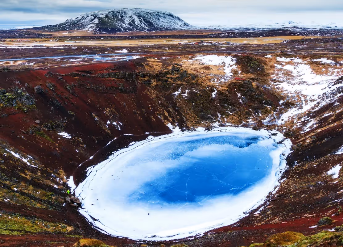
Visiting Kerið crater in winter (November through March) offers a completely different experience from the summer months — one that many experienced Iceland travelers rate as more memorable.
During the winter season, the crater's red volcanic walls may be dusted with snow, creating a stark visual contrast between white snow, red and orange scoria, and the still-vivid lake below. When temperatures drop consistently below 0°C (32°F), the lake can partially or fully freeze, creating a pale, mirror-like surface of ice that reflects the winter sky in a ghostly way — entirely unlike the vivid teal of summer but equally compelling.
The surrounding landscape strips back to bare rock and frost, which paradoxically makes the crater's colors — deep red walls, white snow, pale frozen lake — even more intense in contrast.
Kerið crater has limited accessibility for visitors with reduced mobility. The car park and the initial flat approach to the crater rim are manageable for most visitors. However, the descent path to the lake involves approximately 139 steps and steep, uneven terrain with no alternative accessible route — making it unsuitable for wheelchair users or visitors with significant mobility limitations.
The rim walk itself is on natural unpaved terrain that can be soft or uneven, particularly after rain, which may present challenges for wheelchair users. Families with prams or pushchairs will also find the descent impractical. Visitors with mobility limitations can still experience a genuinely impressive view of the crater from the rim without descending, and the rim vantage point alone is considered exceptional.
Approximately 30 km west of Kerið, Þingvellir is a UNESCO World Heritage Site and one of Iceland's most historically and geologically significant locations. This is where Iceland's first parliament, the Alþing, was established in 930 AD, and where the North American and Eurasian tectonic plates are visibly diverging — pulling apart at a rate of about 2 cm per year.
Visitors can walk along the rift valley, snorkel or dive in the crystal-clear Silfra fissure (one of the only places on Earth to dive between two tectonic plates), and explore the historic parliamentary grounds at Lögberg.
Approximately 35 km northeast of Kerið, the Geysir geothermal area is home to Strokkur — one of the world's most reliably active geysers, erupting every 5 to 10 minutes and shooting boiling water 20 to 40 meters into the air.
The area also features numerous bubbling hot springs, mud pots, and fumaroles spread across a vast geothermal field. This is one of the most visited natural sites in Iceland.
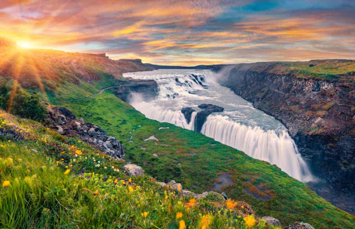
Approximately 40 km northeast of Kerið, Gullfoss is among Iceland's most powerful and iconic waterfalls. The Hvítá River plunges in two dramatic tiers into a narrow canyon, and on sunny days, rainbows form consistently in the spray above the falls. It is a short drive from Geysir and forms the natural end point of the classic Golden Circle route.
Approximately 20 km from Kerið, the Secret Lagoon in Flúðir is one of Iceland's oldest natural geothermal bathing pools. It sits in a rustic outdoor setting surrounded by bubbling hot springs and small geysers, offering a quieter and more natural alternative to the Blue Lagoon.
Water temperature averages around 38–40°C (100–104°F) year-round. A geothermal soak here makes an ideal complement to a crater visit.
Approximately 25 km north of Kerið, Fontana is a modern geothermal spa situated directly on the shores of Lake Laugarvatn. It features multiple outdoor geothermal pools, steam rooms built directly over natural steam vents in the ground, and spectacular views across the lake.
The facility also offers traditional Icelandic rye bread baked underground using geothermal heat.
Approximately 15 km from Kerið, Sólheimar is one of Iceland's most unusual communities — a sustainable ecovillage founded in 1930 that is home to both able-bodied and disabled residents living and working together.
Visitors can explore organic gardens, art studios, a café, and craft workshops. It offers a quieter, more reflective counterpoint to the natural sights of the Golden Circle.
There are no cafés, restaurants, or food outlets at Kerið crater itself. Visitors should plan food stops in nearby towns:
Travelers spending a full day on the Golden Circle are strongly advised to carry snacks, water, and a light meal in the car, as facilities between the main sights are limited and queues at popular spots can be long during peak season.
June – August: 8:30 AM – 9:00 PM (ticket kiosk hours) September – May: Approximately 10:00 AM – 5:00 PM (daylight-dependent)
Kerid crater (also spelled Kerið, Kerio, or Kerith) is a volcanic crater lake located in the Grímsnes area of southern Iceland. It is one of the most visually striking geological features in the country — a deep elliptical caldera with vivid rust-red and orange volcanic walls plunging down to a brilliantly teal-colored lake at the bottom.
The dramatic interplay of colors — crimson scoria, blue-green water, and lush green moss — has earned Kerið the nickname the "Eye of the World," a reference to how the crater resembles a giant eye gazing upward from the earth when viewed from the rim.
Unlike most volcanic craters formed by explosive eruptions, Kerið was created through a gradual process of caldera collapse: the magma chamber beneath the volcano slowly drained and emptied, causing the surface above to cave inward under its own weight. Over thousands of years, groundwater seeped up through the porous volcanic rock and filled the crater floor, forming the lake visible today.
Kerið belongs to the Tjarnarhólar crater group, a chain of volcanic craters aligned along an 800-meter fissure. Of all the craters in this cluster, Kerið is both the northernmost and the most famous, owing to its well-preserved shape, accessible location, and striking appearance.
Kerið is estimated to be approximately 3,000 to 6,500 years old, which makes it extraordinarily young in geological terms. For context, this places its formation well within the period of human civilization, though long before Iceland was settled. Humans first arrived in Iceland around 874 AD — thousands of years after Kerið was already a fully formed, dormant crater.
The crater formed not through a dramatic explosion but through the quieter and equally powerful process of volcanic deflation: as magma drained away underground, the ground above it lost its structural support and collapsed inward, creating the bowl shape seen today.
Kerið was historically owned by private Icelandic landowners and was one of the few natural attractions in Iceland to charge an entrance fee even before tourism became a major industry in the country. In 2023, the site was purchased by Arctic Adventures, an Icelandic adventure tour company, which now manages the site, maintains its facilities, and operates the admission system.
The red and orange colors of the crater walls come from scoria — a highly porous volcanic rock with a high iron content. When the iron in the rock oxidizes (essentially rusts), it produces the characteristic warm red and orange tones that dominate the crater's slopes. Green vegetation — mosses and grasses — clings to the upper portions of the walls, adding another striking layer to the color contrast.
The lake's teal-blue color is caused by minerals dissolved into the groundwater from the surrounding volcanic rock. Water levels fluctuate between seasons: higher in spring following snowmelt, lower in late summer. The lake is fed entirely by groundwater rising through the earth, not by surface rainfall or inflowing rivers.
Kerið crater is situated in the Grímsnes area of southern Iceland, along Route 35 (Biskupstungnabraut). It sits between the town of Selfoss to the south and the Geysir geothermal area to the north, placing it directly on one of Iceland's most heavily traveled tourist routes.
Kerið crater coordinates: 64.0419° N, 20.8853° W
Kerið crater address: Route 35, Grímsnes, South Iceland. Searching "Kerið Crater" in Google Maps or any GPS navigation app will bring you directly to the site. The crater is well-signposted along Route 35 in both directions and visible from the road.
Kerið is approximately 55–70 km (34–43 miles) from Reykjavík city center — roughly a 50 to 60-minute drive under normal conditions, making it one of the most accessible major natural attractions in Iceland.
For travelers who prefer not to self-drive, Golden Circle tours from Reykjavík are the most popular way to visit Kerið. Many tour operators include Kerið as a dedicated stop — either as part of an extended Golden Circle package or as an add-on.
Tours depart daily from Reykjavík, typically include hotel pickup, and cover the major Golden Circle sights. Kerið usually serves as either the first or the final stop of the day. Advance booking is strongly recommended during the summer months (June–August).
Kerið crater is not part of the classic three-stop Golden Circle route — which traditionally covers Þingvellir National Park, the Geysir geothermal area, and Gullfoss waterfall — but it is so closely associated with the route that it is widely considered the Golden Circle's most popular bonus attraction.
The crater sits directly on Route 35, the same road linking all the Golden Circle sites, placing it approximately 17 miles (28 km) from both Þingvellir and Geysir. This makes it a completely seamless and logical addition to any Golden Circle itinerary with virtually no detour required. Most tour operators now offer extended Golden Circle Itinerary that include Kerið as a fourth stop, and visitors who skip it often report it as one of their biggest regrets.
Kerið crater sits on private land managed by Arctic Adventures, so an admission fee is required to enter the site.
Payment is accepted by credit or debit card at the ticket kiosk near the car park entrance. Online pre-booking is available through the Arctic Adventures website — advisable during peak summer months to avoid queues at the kiosk.
Parking at Kerið crater is completely free. A dedicated car park sits directly beside the crater entrance and accommodates both private vehicles and tourist coaches. The car park can fill during peak summer midday hours; arriving early morning or late afternoon is recommended to avoid congestion.
Kerið Crater Opening Hours
Kerið operates on a daylight-dependent schedule. During Iceland's Midnight Sun season (mid-May through late July), the site is effectively accessible around the clock since true darkness never falls.
In the depths of winter, daylight is limited to a narrow window — roughly 10:00 AM to 3:30 PM in December and January — making careful timing essential. The ticket kiosk operates during the hours listed above; access outside those hours may be restricted.
The crater rim trail is a flat, circular path that takes approximately 15 to 20 minutes to walk in full. It loops around the entire perimeter of the caldera, offering constantly shifting perspectives of the lake below and the volcanic landscape beyond.
Every angle delivers a dramatically different but equally rewarding view — walking the full circuit rather than stopping at the first viewpoint is strongly recommended. The path is unpaved natural terrain, easy for most fitness levels, though grippy footwear is advised, particularly after rain.
A dedicated path with approximately 139 steps and several steep inclines descends from the crater rim down to the edge of the lake. The descent dramatically transforms the experience: from the lakeside, the crater walls tower overhead on all sides, the sense of scale becomes genuinely immersive, and the stillness at the bottom of the caldera — naturally sheltered from wind by the surrounding walls — creates an atmosphere of remarkable calm.
The lake up close is extraordinarily vivid, the water appearing almost luminescent depending on the light and season. The descent and return to the rim take approximately 15 to 20 additional minutes beyond the rim walk.
Viewed from the rim — particularly looking straight down the slope at the lake — Kerið crater bears a striking resemblance to a giant eye: the teal lake forms the iris, the oval caldera forms the eyelid shape, and the depth and curvature of the volcanic walls create a sense of looking into something alive and watching.
This visual likeness has given Kerið its widely used nickname, the Kerið crater Eye of the World (also called the Kerið crater lake eye). The image is immediately recognizable and has become one of the defining visual symbols of Icelandic tourism.
Kerið is one of the most photographed natural sites in Iceland, offering exceptional shooting opportunities from multiple vantage points. From the rim, wide-angle shots capture the full elliptical caldera with the lake below. From the lakeside at the bottom, looking upward at the towering red walls framing an oval of sky creates an entirely different and equally powerful image.
Early morning and late evening light — low, warm, and directional — enhances the deep red tones of the scoria dramatically. In winter, snow on the crater walls and a partially or fully frozen lake add layers of visual complexity unavailable in summer.
Important: Drone flights are strictly prohibited at Kerið crater and can result in a fine. This rule is actively enforced.
Visiting Kerið crater in winter (November through March) offers a completely different experience from the summer months — one that many experienced Iceland travelers rate as more memorable.
During the winter season, the crater's red volcanic walls may be dusted with snow, creating a stark visual contrast between white snow, red and orange scoria, and the still-vivid lake below. When temperatures drop consistently below 0°C (32°F), the lake can partially or fully freeze, creating a pale, mirror-like surface of ice that reflects the winter sky in a ghostly way — entirely unlike the vivid teal of summer but equally compelling.
The surrounding landscape strips back to bare rock and frost, which paradoxically makes the crater's colors — deep red walls, white snow, pale frozen lake — even more intense in contrast.
Kerið crater has limited accessibility for visitors with reduced mobility. The car park and the initial flat approach to the crater rim are manageable for most visitors. However, the descent path to the lake involves approximately 139 steps and steep, uneven terrain with no alternative accessible route — making it unsuitable for wheelchair users or visitors with significant mobility limitations.
The rim walk itself is on natural unpaved terrain that can be soft or uneven, particularly after rain, which may present challenges for wheelchair users. Families with prams or pushchairs will also find the descent impractical. Visitors with mobility limitations can still experience a genuinely impressive view of the crater from the rim without descending, and the rim vantage point alone is considered exceptional.
Approximately 30 km west of Kerið, Þingvellir is a UNESCO World Heritage Site and one of Iceland's most historically and geologically significant locations. This is where Iceland's first parliament, the Alþing, was established in 930 AD, and where the North American and Eurasian tectonic plates are visibly diverging — pulling apart at a rate of about 2 cm per year.
Visitors can walk along the rift valley, snorkel or dive in the crystal-clear Silfra fissure (one of the only places on Earth to dive between two tectonic plates), and explore the historic parliamentary grounds at Lögberg.
Approximately 35 km northeast of Kerið, the Geysir geothermal area is home to Strokkur — one of the world's most reliably active geysers, erupting every 5 to 10 minutes and shooting boiling water 20 to 40 meters into the air.
The area also features numerous bubbling hot springs, mud pots, and fumaroles spread across a vast geothermal field. This is one of the most visited natural sites in Iceland.
Approximately 40 km northeast of Kerið, Gullfoss is among Iceland's most powerful and iconic waterfalls. The Hvítá River plunges in two dramatic tiers into a narrow canyon, and on sunny days, rainbows form consistently in the spray above the falls. It is a short drive from Geysir and forms the natural end point of the classic Golden Circle route.
Approximately 20 km from Kerið, the Secret Lagoon in Flúðir is one of Iceland's oldest natural geothermal bathing pools. It sits in a rustic outdoor setting surrounded by bubbling hot springs and small geysers, offering a quieter and more natural alternative to the Blue Lagoon.
Water temperature averages around 38–40°C (100–104°F) year-round. A geothermal soak here makes an ideal complement to a crater visit.
Approximately 25 km north of Kerið, Fontana is a modern geothermal spa situated directly on the shores of Lake Laugarvatn. It features multiple outdoor geothermal pools, steam rooms built directly over natural steam vents in the ground, and spectacular views across the lake.
The facility also offers traditional Icelandic rye bread baked underground using geothermal heat.
Approximately 15 km from Kerið, Sólheimar is one of Iceland's most unusual communities — a sustainable ecovillage founded in 1930 that is home to both able-bodied and disabled residents living and working together.
Visitors can explore organic gardens, art studios, a café, and craft workshops. It offers a quieter, more reflective counterpoint to the natural sights of the Golden Circle.
There are no cafés, restaurants, or food outlets at Kerið crater itself. Visitors should plan food stops in nearby towns:
Travelers spending a full day on the Golden Circle are strongly advised to carry snacks, water, and a light meal in the car, as facilities between the main sights are limited and queues at popular spots can be long during peak season.
Kerid Crater Lake was formed around 3,000 years ago due to a volcanic eruption that caused the top of a volcanic cone to collapse inward, creating a crater that eventually filled with water.
Yes, there is a walking path around the rim of the crater, offering panoramic views of the lake and the surrounding landscape. You can also hike down to the water’s edge.
Kerid Crater Lake can be visited year-round, but the best time is during the summer when the weather is mild and the vibrant colors of the lake and surrounding landscape are most striking.
Swimming is not allowed in Kerid Crater Lake to preserve the natural environment and maintain the cleanliness of the water.
While not an official part of the Golden Circle, Kerid Crater Lake is located nearby and is a popular stop for those touring the Golden Circle attractions.
Why should you?